By MetService Weather Ambassador, Bob McDavitt
A fact sheet on how the weather is forecast compiled by the Science Media Centre.
Droughts have more impact than floods
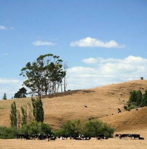
The Waikato drought lasted mainly from November 2007 to April 2008, with some places around Hamilton having the lowest rain amounts ever recorded. The cost of the drought is reckoned to be $1.5 billion to the Dairy sector alone, and was one of the factors that threw New Zealand’s economy into recession by mid 2008.
Waikato drought Dec 2007 to April 2008
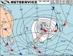
For flood damage the Insurance council of New Zealand’s web site that shows the cost of insured weather damage payouts in New Zealand (at http://www.icnz.org.nz/current/weather) for 2008 stands (to end of November) at $68.5 million, compared with $85.3 million for 2007. The main storm for 2008, as measured by insured loss payouts, was $42 million for the storm in late July that affected much of the country. In second place came the weather bomb of 26 July, covered in last September’s Kiwifruit Journal.
Here is a brief summary of the main weather events for the past year.
Summer drought
On the 20th December (the day of the Gisborne earthquake that caused $30.5 million of insurance claims) a southerly change brought surface flooding to Christchurch city and snow fell to 700m on central Otago hills and Southern Alps. On the 30th downpours caused the evacuation of six houses in Ashburton and a camping ground near Geraldine.
In January dry anticyclones lingered over central or southern parts of the country. Places reporting less than 10 mm of rain during the month were Paeroa, Hamilton, Cape Campbell, Kaikoura, and Le Bons Bay. Early in January the roads around Levin and the Waikanae camping grounds were flooded. On the 22nd the remains of Cyclone FUNA crossed the central South Island bringing 200 to 300 mm of rain over the Tasman ranges and producing severe gales over southern parts of the North Island that fanned fires and damaged powerlines.
By early February, Waikato was declared to be a drought area. During February four significant lows approached from the subtropics, but these all failed to deliver any significant rain to the region between Waikato and Marlborough.
Cyclone GENE diverted to the east on 5-8 February. On 11 February a low from Sydney moved across the South Island and triggered thunderstorms, hail, and flash flooding in North Canterbury and around Lower Hutt. On the 15 and 16 February a low did a loop off the Canterbury coast and brought between 30 and 70 mm of rain to Canterbury and gusts of 93 km/hr to Lyttelton.
A waterspout was seen making landfall at Queen Elizabeth II Park near Raumati. On 22 and 23 February a low from the Coral Sea crossed Northland and brought between 200 and 240 mm of rain to the hills between Kaeo and Kaikohe, flooding the roads around Kaeo.
Autumn lightning change
In March, several large anticyclones lingered over central New Zealand and produced extended periods of settled weather. A heat wave in Australia around mid-March extended to NZ on 19 March with Timaru’s temperature reaching 34C.
On April 8th a front brought heavy rain to the Gisborne hills. On 15 April a front brought thundery downpours to the north of the North Island accompanied by heavy lightning (reaching 1000 strikes per hour) with one strike killing a horse and rider near Dargaville. A flash flood in a canyon on the Mangatepopo stream near Turangi took the lives of 7 out of a group of 12. This rain marked the beginning of the end of the Waikato drought. The first polar blast of the year arrived on 18 to 20 April and brought a dusting of snow to Clinton. On 29 and 30 April widespread rain brought surface flooding in Taranaki and Rotorua, slips closed roads near Whangarei, and a tornado caused a power outage in Tarawera.
There was a cold snap at the start of the May, with hail in Dunedin and Christchurch, snow that closed the Gentle Annie Road between Taihape and Napier, and a nine degree frost at Invercargill. On 9 May heavy rain flooded Te Puia springs. A clear calm night on 16 May caused black ice on the Desert Road, and fog that closed Auckland and Hamilton airports until 1pm. On 22 May a cold front brought the first substantial snow fall of the year to central Otago mountains. After that, a sustained easterly flow kept generally wet conditions on the North Island’s east coast until Queen’s Birthday weekend with slips that closed the road between Wairoa and Lake Waikaremoana on the 24th.
Winter storms
In March, several large anticyclones lingered over central New Zealand and produced extended periods of settled weather. A heat wave in Australia around mid-March extended to NZ on 19 March with Timaru’s temperature reaching 34C.
On April 8th a front brought heavy rain to the Gisborne hills. On 15 April a front brought thundery downpours to the north of the North Island accompanied by heavy lightning (reaching 1000 strikes per hour) with one strike killing a horse and rider near Dargaville. A flash flood in a canyon on the Mangatepopo stream near Turangi took the lives of 7 out of a group of 12. This rain marked the beginning of the end of the Waikato drought. The first polar blast of the year arrived on 18 to 20 April and brought a dusting of snow to Clinton. On 29 and 30 April widespread rain brought surface flooding in Taranaki and Rotorua, slips closed roads near Whangarei, and a tornado caused a power outage in Tarawera.
There was a cold snap at the start of the May, with hail in Dunedin and Christchurch, snow that closed the Gentle Annie Road between Taihape and Napier, and a nine degree frost at Invercargill. On 9 May heavy rain flooded Te Puia springs. A clear calm night on 16 May caused black ice on the Desert Road, and fog that closed Auckland and Hamilton airports until 1pm. On 22 May a cold front brought the first substantial snow fall of the year to central Otago mountains. After that, a sustained easterly flow kept generally wet conditions on the North Island’s east coast until Queen’s Birthday weekend with slips that closed the road between Wairoa and Lake Waikaremoana on the 24th.
 Weather map for the 26th July Weather Bomb
In March, several large anticyclones lingered over central New Zealand and produced extended periods of settled weather. A heat wave in Australia around mid-March extended to NZ on 19 March with Timaru’s temperature reaching 34C.
On April 8th a front brought heavy rain to the Gisborne hills. On 15 April a front brought thundery downpours to the north of the North Island accompanied by heavy lightning (reaching 1000 strikes per hour) with one strike killing a horse and rider near Dargaville. A flash flood in a canyon on the Mangatepopo stream near Turangi took the lives of 7 out of a group of 12. This rain marked the beginning of the end of the Waikato drought. The first polar blast of the year arrived on 18 to 20 April and brought a dusting of snow to Clinton. On 29 and 30 April widespread rain brought surface flooding in Taranaki and Rotorua, slips closed roads near Whangarei, and a tornado caused a power outage in Tarawera.
There was a cold snap at the start of the May, with hail in Dunedin and Christchurch, snow that closed the Gentle Annie Road between Taihape and Napier, and a nine degree frost at Invercargill. On 9 May heavy rain flooded Te Puia springs. A clear calm night on 16 May caused black ice on the Desert Road, and fog that closed Auckland and Hamilton airports until 1pm. On 22 May a cold front brought the first substantial snow fall of the year to central Otago mountains. After that, a sustained easterly flow kept generally wet conditions on the North Island’s east coast until Queen’s Birthday weekend with slips that closed the road between Wairoa and Lake Waikaremoana on the 24th.
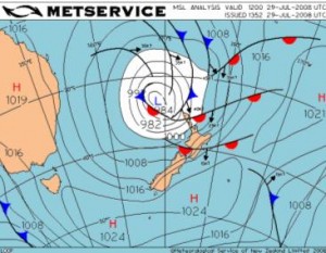
 Weather map showing the 29th-31st July 2008 low
The next low wasn’t as deep but took a path slowly southwards from west of Northland to east of Otago on 29, 30, 31 July. Two people drowned fording a stream near Kawakawa. Coromandel Ranges (Golden Cross) had 312 mm of rain in two days. Slips closed roads in Northland, Auckland, Coromandel Peninsula, Waikato, Gisborne, Hawke’s Bay, Marlborough, Canterbury, and Otago. A large slip between Kaikoura and Cheviot disrupted road and rail for days.
Around Horowhenua high winds caused extensive damage and power outages affected Levin. Severe gales also brought damage to Nelson, Buller and Westland, with gusts measured at 160 km/hr in Greymouth and 130 km/hr in Nelson where a video was taken of a falling tree just missing a passing car. With $42 million of insurance claims, this was the year’s most expensive storm in New Zealand.
Most places about and south of Rotorua had their coldest day of winter on 9 August with highs ranging from 5ºC at Christchurch to 10ºC at New Plymouth and Napier. From 13th to 16th August a low in the Southern Ocean brought very cold showery westerlies with rain or snow to many areas. Heavy snow fell in Nelson, Buller and Westland, with 20 cm reported at Murchison and 25 cm at Arthurs Pass. The Tararua Ranges had 200 mm of rain in three days, and a peak flow in the Waikato River on 16 August burst stop banks near Huntly. On 24th to 26th August a frontal system stalled over Marlborough and North Canterbury, causing further slips that closed roads and rail links. There were $5 million in insurance claims.
Spring up and down
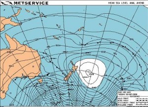
An intense anticyclone passed to the north of the Chatham Islands on 1and 2 September with a drifting buoy recording 1047.0 hPa. The fronts that followed this anticyclone brought large rainfalls to Westland on 2, 3, 4 September and to the Southern Alps on 15, 21, 23 and 27 September, helping to replenish the southern hydro lakes. The front on 23 September also triggered a large landslip on Mount Underwood that closed the Milford Road for four days.
Weather map for 2 September 2008 – an extreme anticyclone.
Also on 23 September northwesterly wind gusts ahead of a front reached 75 knots over Rimutaka Hill Road, and brought record breaking temperatures at Timaru (27°C), Dunedin and Kaikoura (26°C). A cold front on 27 September was preceded by northwest winds that knocked over some trees in Canterbury and accompanied by a brief fall of snow down to 200 metres in Southland and Otago that delayed the start to Alexandra’s Blossom Festival.
October was windy: westerly gusts on 4 October toppled a campervan at Mt Hutt and fanned fires that burnt a pine plantation at Little River. On 7 October Wellington Airport was closed for half the day by gusts to 70 knots, and a truck flipped in Wairarapa. The same northwest flow brought gusts to 75 knots to Manukau Heads and knocked over a nearby barn, breaking the occupant’s leg. Heavy rain fell swelled a stream on Mt. Taranaki taking the life of a tramper. Further westerly gales on the 9th, 20th and 28th Oct affected traffic on the Rimutaka road. A tornado damaged several houses in Cambridge on 17 October.
During November anticyclones lingered to east of New Zealand making for a dry time for eastern districts. A cold polar outbreak around Guy Fawkes Day brought unseasonal amounts of snow to Southland and a rouge severe frost to the Christchurch area. On 17 Nov parts of Ashburton were damaged by walnut-sized hail. And late in November a warm and muggy northerly flow brought heavy rain to Westland, Buller and Nelson, flooding Takaka.
Weather patterns for this summer
After the longest day on 22 December we shall be moving towards the warmest time of the year during January and February. MetService and NIWA latest seasonal outlook states that this period is NOT likely to be as hot and dry as the LA NINA summer we had last time. The sea surface temperatures in the equatorial Pacific are around normal and that indicates we are in neutral territory, neither a La Nina nor an El Nino, but the Southern Oscillation index shows a tendency towards a weak La Nina. Anticyclones will have more latitude to play this summer, and this allows an increased variety in the weather and reduces the confidence we can have in the seasonal outlooks.
If weather patterns were like musical instruments in an orchestra then when La Nina is the conductor, slower tunes may be favoured, played by the stringed instruments – analogous to the hot dry anticyclones of last summer. However, when El Nino is the conductor, he prefers the strident marching sounds from the brass section of the orchestra, analogous to the cold outbreak that brought snow and hail to the country in early and mid November. Well, this summer we are picking that neither La Nina nor El Nina will be the conductor – in other words “weather jazz”. Just as a jazz group allows each instrument in succession to play a solo piece, so will the weather patterns typical of La Nina and El Nino take turns to dominate our weather. For a week of so we will have northerly wind patterns, and then for the next week or so, southerly wind patterns.
There is a slight hint of a weak La Nina in the atmosphere and that may show itself as favouritism for anticyclones to cross the South Island and linger around Chatham Islands bringing more northwesterly winds than normal to the South Island, and periods of settled sunny weather to eastern districts, suitable for hay-making.
Between the anticyclones, fronts and troughs are expected to cross the country. Some fronts may be preceded by humid warm northerly winds, flowing in from New Caledonia or the Coral Sea where the sea is warmer than normal, and these are likely to bring the wettest episodes of summer, targeting northern and western districts. Some may be followed by cold southerlies, bringing squally thunderstorms and maybe even some hail.
Take special note of any weather map that shows an anticyclone over Chatham Islands and a low pressure system to the north. This is the recipe in northeastern districts for a period of vigorous easterly winds with driving rain. These “easterly events” only last a day or so, so you do NOT need to change your holiday plans on their account.
Indications are that there should be a late start to the tropical cyclone season. At this stage the chances that a cyclone may reach us from the tropics are considered to be slightly above the climatological average of 0.8 tropical cyclones per season.
Updates available from www.metservice.com

