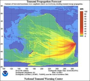
 A two metre-high tsunami has been generated after a magnitude 8.2 earthquake in the Pacific Ocean off Chile earlier today.
The US Geological Survey (USGS) says the quake was centred 86km north-west of Iquique in northern Chile. A tsunami warning has been issued for Chile, Peru and Ecuador and a tsunami watch is in effect for Colombia, Panama and Costa Rica. There is currently no tsunami threat to New Zealand.
The Australian Science Media Centre rounded up the following expert comments:
Professor James Goff, tsunami scientist at the School of Biological, Earth and Environmental Sciences at the University of New South Wales, comments:
“This is a magnitude 8.2 from around the Iquique, essentially this is the area where the 1868 tsunami came from. That event, which was a distantly generated event, was the largest one to have affected New Zealand, and also affected the East Australian coastline, such as Tasmania as well as the east coast around Sydney and parts of the south coast. The effect however isn’t as large as seen in New Zealand as it acts as a barrier for Australia.
“Today’s earthquake is smaller than the 1868 earthquake, which was an 8.5 and was also shallower, but it will still undoubtedly generate a tsunami that will affect New Zealand. But at the moment we’re just not sure of the size but it will not be large. It’s a delicate balance between the magnitude and the depth of the quake.
“We’re just not sure right now how big the tsunami will be. It’s a case of waiting to see the reports of wave heights around Chile and as it comes across the Pacific. We’re just watching and waiting.”
Tom Worthington, Adjunct Senior Lecturer in the Research School of Computer Science at The Australian National University comments:
“The Pacific Tsunami Warning System worked as designed, detecting the earthquake off Chile and transmitting the warning to national authorities. However, problems remain at the local level in getting the warning to residents and in providing them with useful information on what action to take.
“The Pacific Tsunami Warning Centre issued its first bulletin for the Chile earthquake at 23:55 GMT on 1 April 2014. This was an “Expanding Regional Warning”, indicating a potential misname covering a significant area, but not the whole Pacific. The latest bulletin at 0235 GMT on 2 April 2014 narrowed the area to CHILE and PERU. The highest recorded wave was 2.11M at IQUIQUE CL.
“Fortunately, in this case it appears the tsunami was small and the warning was received in time. However, there has been some damage due to the direct effect of the earthquake. As a member of the Sahana Software Foundation I help with the development of free software used to coordinate disaster relief operations around the world (and teach these techniques to ANU students). The software was used for the 2007 Ica Earthquake in Peru and 2012 wildfires in Chile.”
Dr Behzad Fatahi, Senior Lecturer of Geotechnical and Earthquake Engineering and a Chartered Professional Engineer (CPEng) at the University of Technology Sydney comments:
“A magnitude 8.2 shallow earthquake (20.1km below the surface) occurred on 1 April 2014 in northern Chile. This region is a highly active subduction zone that has experienced several large interpolate earthquakes over last 50 years. The last major earthquake in Chile was the 2010 Chile earthquake with the magnitude of 8.8, which was the sixth largest earthquake ever to be recorded by seismographs. Landslides will be the major concern, causing major disruptions and damage near the Chilean coast due to this recent earthquake. In particular, highways connecting Tocopilla and Iquique cities are most susceptible to landslides. In addition, strong amplification of shaking in the areas with soft soils (e.g. Arica, Tocopilla, and Iquique cities) may cause severe damage to buildings, road pavements, and buried services. In Iquique city which is the closest city to the earthquake epicentre, many structures were built on several meters of sand over igneous bedrock, so liquefaction may concern some buildings.”
Dr Catherine Chagué-Goff, School of Biological, Earth and Environmental Sciences at the University of New South Wales and the Institute for Environmental Research at the Australian Nuclear Science and Technology Organisation comments:
“The 1 April 2014 M8.2 earthquake in northern Chile (Iquique) occurred on the Nazca-South American plate boundary, which is one of the most seismically-active areas worldwide. As a result Chile experiences one great megathrust earthquake every 100-200 years in any segment of the subduction zone. Many of these large earthquakes have also generated tsunamis, which affected not only South America, but also regions around the Pacific: e.g. Arica 1604 (M8.4), Concepcion 1835 (M8.2), Arica 1868 (M8.5), Iquique 1877 (M8.3), Atacama 1922 (M8.7), Valdivia 1960 (the largest recorded earthquake in historical times M9.5), Maule 2010 (M8.8).
“The last earthquake that occurred in the Iquique seismic gap, where the subducting (Nazca) and overriding (South American) plates are partially to fully-locked, was a M8.3 earthquake on 9 May 1877, which also triggered a tsunami. The death toll from the earthquake and tsunami was nearly 2500 people.
“The Pacific Tsunami Warning Centre reports that tsunami waves about 2 m high were recorded in Iquique and Pasagua. In Arica (140 km NW of the epicentre), a 1.3 m high wave was reported. There is still a tsunami watch and alert for Chile and Peru. Coastal areas of Chile and neighbouring Peru have been evacuated.”