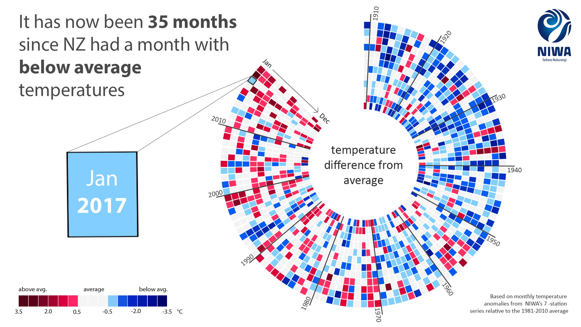
Last year was New Zealand’s fourth warmest year since recording began in 1909, according to the 2019 Niwa Annual Climate Summary.
Annual temperatures were +0.5 to +1.2 degrees Celsius above the annual average across the majority of New Zealand, the report found.
While yearly rainfall in 2019 was above average in western Southland and parts of Westland, large areas of the country – including Northland, Auckland, the Bay of Plenty and parts of Waikato, Hawke’s Bay, the Wairarapa and Marlborough – had only 50–80 per cent of their usual rainfall.
The SMC asked experts to comment on the summary. Feel free to use these comments in your reporting.
Professor James Renwick, School of Geography, Environment and Earth Sciences, Victoria University of Wellington, comments:
“It has now been 35 months since New Zealand had a month with below-average temperatures’, according to the NIWA infographic that accompanies the 2019 annual climate summary.
“New Zealand has a temperate and variable climate, and 2019 was no exception. But the trend towards warming shows that we are affected by climate change, along with the rest of the globe.
“The year 2019 was our 4th warmest on record. In the past 20 years, only four had annual mean temperatures below the 1981-2010 average, so 80% of those years were warmer than average. In the first 20 years of the record (1909-1928), only four (20%) had annual mean temperatures above the 1981-2010 average. That’s how a warming climate works, we see ups and downs but the chances of a warm year are increasing all the time.
Warm seas were a feature of the climate in 2019, at the start of the year and again in November, coinciding with record warmth in many New Zealand locations.
“There were some cold spells in 2019, with a dozen daily low temperature records broken. But they were far outweighed by high temperatures, with over 100 new daily high temperature records broken.
“The Southern Annular Mode played an active role in New Zealand’s weather during 2019. The Southern Annular Mode involves the north-south movement of the strong westerly belt and its associated region of storms. When the Southern Annular Mode is positive, the strong winds and storms sit over the southern ocean, comfortably away from New Zealand. When the Southern Annular Mode is negative, such as in August, the westerlies and the storms move north over New Zealand and our weather becomes more unsettled. The Southern Annular Mode has been persistently negative almost every day since mid-October, an unusually long spell, contributing to an unsettled start to the summer.
“The westerly winds that blow across the country were a little stronger than normal for the year as a whole, contributing to the pattern of dry conditions in the north and east of the North Island and wet conditions in the west of the South Island. This pattern is what we are likely to see more of as the climate changes this century, with more frequent drought (and increased fire danger) in eastern regions and in the northern North Island. Heavy rainfall events were peppered around the country as usual, with quite a few thunderstorm events with hail and lightning. The average amount of moisture (water vapour) in the air is strongly related to temperature, so as the climate warms, heavy rainfalls become heavier and flooding becomes more common. The phenomenal metre of rain that fell in two days at Cropp River is something that we are likely to see more of, and see exceeded, in future years.
“Thanks to NIWA for an excellent summary of 2019, a real treasure trove of information for weather and climate enthusiasts.”
Declared conflict of interest: None.
Lisa Murray, MetService Meteorologist and Head of Weather Communication comments:
“Another year and more records broken! While many individual stations, like the MetService station in Tauranga, have seen their warmest year on record, 2019 has been the 4th warmest year overall. This continues the warming trend we have seen in recent years, as five of the last seven years have been amongst the hottest on record for New Zealand. The knock-on effect of this is we start 2020 with many eastern and northern regions of the country thirsty for some significant rainfall.
“One of the standout weather events of 2019 happened on the West Coast of the South Island on March 25–26th. A warm sea combined with moisture from the Tropics helped intensify a stalled front, producing an extreme rainfall event. Rain gauges recorded 500-700mm along the Southern Alps, with some alpine locations recording 700-1100mm. A State of Emergency was declared for Westland as roads and bridges (the Waiho) were washed away, and major flooding occurred isolating communities.
“Being informed of oncoming severe weather is becoming increasingly important in a changing climate where new extremes are being observed each year. In 2019 MetService issued official Severe Weather Warnings for 65 separate events. Mid-2019 MetService introduced a Severe Weather Red Warning which will be used for destructive weather events to help people understand their significance so they can ‘take immediate action’ to prepare.”
Declared conflict of interest: None.
